
Fichier:Ny.terra.600pix.jpg

Fichier d’origine (600 × 796 pixels, taille du fichier : 164 kio, type MIME : image/jpeg)
Ce fichier et sa description proviennent de Wikimedia Commons.

|
Ce fichier a été transféré sur Commons depuis en.wikipedia, de façon semi-automatique. Toutes les informations d'origine sont encore présentes, et il faut les vérifier. Il peut y avoir des erreurs dans la description, les catégories peuvent ne pas être les bonnes, ne faites pas confiance à cette description tant que ce bandeau est présent. Vous pouvez enlever le bandeau une fois que la description et les catégories ont été vérifiées. Vérifiez maintenant ! |
| Description |
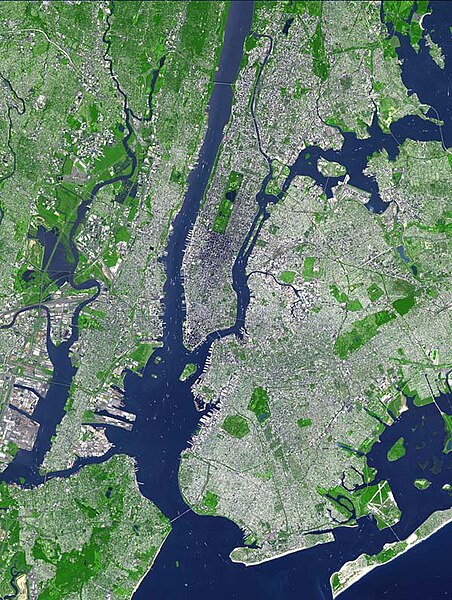
English: This false-color satellite image shows Greater New York City.
The Island of Manhattan juts southward from top center, bordered by the Hudson River to the west and the East River to the east (north is straight up in this scene.) In the middle of Manhattan, Central Park appears as a long green rectangle running roughly north-south with a large lake in the middle. Also visible are parts of Staten Island (bottom left corner) and Long Island (lower right). This false-color image was acquired on Sept. 8, 2002, by the Advanced Spaceborne Thermal Emission and Reflection Radiometer (ASTER) aboard NASA's Terra satellite. The scene spans an area that is 27 km wide by 37 km tall. Vegetated land surface is green, paved urban areas are a whitish blue, and water is dark blue. |
| Date | |
| Source |
SOURCE: http://earthobservatory.nasa.gov/Newsroom/NewImages/images.php3?img_id=15368 The purpose of NASA's Earth Observatory is to provide a freely-accessible publication on the Internet where the public can obtain new satellite imagery and scientific information about our home planet. The focus is on Earth's climate and environmental change. In particular, we hope our site is useful to public media and educators. Any and all materials published on the Earth Observatory are freely available for re-publication or re-use, except where copyright is indicated. We ask that NASA's Earth Observatory be given credit for its original materials. Picture prepared for Wikipedia by Adrian Pingstone in November 2003. ) |
| Auteur | Image courtesy NASA/GSFC/MITI/ERSDAC/JAROS, and U.S./Japan ASTER Science Team |
Conditions d’utilisation
| Ce fichier provient de la NASA. Sauf exception, les documents créés par la NASA ne sont pas soumis à copyright. Pour plus d'informations, voir la politique de copyright de la NASA. | ||
 |
Attention :
|
Journal des téléversements d’origine
- 2004-05-16 03:50 Aramgutang 600×796× (167781 bytes) Reverted to earlier revision
- 2004-05-16 03:49 Aramgutang 600×796× (167781 bytes) Reverted to earlier revision
- 2003-11-06 19:15 Arpingstone 600×796× (167781 bytes) New York from space
- 2003-11-06 19:11 Arpingstone 600×796× (167781 bytes) New York from space
Historique du fichier
Cliquer sur une date et heure pour voir le fichier tel qu'il était à ce moment-là.
| Date et heure | Vignette | Dimensions | Utilisateur | Commentaire | |
|---|---|---|---|---|---|
| actuel | 12 janvier 2010 à 15:20 | | 600 × 796 (164 kio) | File Upload Bot (Magnus Manske) | {{BotMoveToCommons|en.wikipedia|year={{subst:CURRENTYEAR}}|month={{subst:CURRENTMONTHNAME}}|day={{subst:CURRENTDAY}}}} {{Information |Description={{en|This false-color satellite image shows Greater New York City. The Island of Manhattan juts southward fr |
Utilisation du fichier
La page suivante utilise ce fichier :
Usage global du fichier
Les autres wikis suivants utilisent ce fichier :
- Utilisation sur ar.wikipedia.org
- Utilisation sur ast.wikipedia.org
- Utilisation sur en.wikipedia.org
- Utilisation sur id.wikipedia.org
- Utilisation sur ja.wikipedia.org
- Utilisation sur ky.wikipedia.org
- Utilisation sur www.wikidata.org