
Fichier:NiigataMapCurrent.png

Taille de cet aperçu : 800 × 522 pixels. Autres résolutions : 320 × 209 pixels | 640 × 418 pixels | 1 024 × 668 pixels | 1 381 × 901 pixels.
Fichier d’origine (1 381 × 901 pixels, taille du fichier : 45 kio, type MIME : image/png)
Ce fichier et sa description proviennent de Wikimedia Commons.

|
Cette image (de type locator map) devrait être recréée dans un format vectoriel, en tant que fichier SVG. Cela offrirait plusieurs avantages : voir Commons:Media for cleanup pour plus d'informations. Si une version SVG de cette image est déjà disponible, merci de bien vouloir l'envoyer. Après cela, remplacez ce modèle par {{vector version available|nouveau nom d'image.svg}}.
|
Description
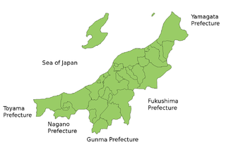
Map of Niigata Prefecture, Japan.
Thanks to Aoki Shigenobu and [1]. Colors from Image:TokyoMapCurrent.png by User:Fg2.
Conditions d’utilisation
| Moi, propriétaire des droits d’auteur sur cette œuvre, la place dans le domaine public. Ceci s'applique dans le monde entier. Dans certains pays, ceci peut ne pas être possible ; dans ce cas : J’accorde à toute personne le droit d’utiliser cette œuvre dans n’importe quel but, sans aucune condition, sauf celles requises par la loi. |
Historique du fichier
Cliquer sur une date et heure pour voir le fichier tel qu'il était à ce moment-là.
| Date et heure | Vignette | Dimensions | Utilisateur | Commentaire | |
|---|---|---|---|---|---|
| actuel | 28 septembre 2011 à 22:46 | | 1 381 × 901 (45 kio) | Haaninjo | Mergers into Murakami (and a Kawaguchi-Nagaoka merger that didn't change any boundaries). |
| 11 juin 2007 à 15:27 |  | 1 381 × 901 (46 kio) | Alberth2 | ||
| 4 avril 2007 à 20:59 |  | 1 381 × 901 (33 kio) | Tene~commonswiki | Optimised (0) | |
| 22 juillet 2006 à 04:50 |  | 1 381 × 901 (45 kio) | Akanemoto~commonswiki | ||
| 19 juillet 2006 à 19:31 |  | 1 281 × 901 (43 kio) | Akanemoto~commonswiki | Map of Niigata Prefecture, Japan. Thanks to Aoki Shigenobu and [http://aoki2.si.gunma-u.ac.jp/map/map.html]. Colors from Image:TokyoMapCurrent.png by User:Fg2. Category:Maps of Niigata prefecture Category:Maps in English |
Utilisation du fichier
La page suivante utilise ce fichier :
Usage global du fichier
Les autres wikis suivants utilisent ce fichier :
- Utilisation sur az.wikipedia.org
- Utilisation sur be.wikipedia.org
- Utilisation sur ckb.wikipedia.org
- Utilisation sur cs.wikipedia.org
- Utilisation sur es.wikipedia.org
- Utilisation sur es.wikivoyage.org
- Utilisation sur eu.wikipedia.org
- Utilisation sur fi.wikipedia.org
- Utilisation sur hu.wikipedia.org
- Utilisation sur jv.wikipedia.org
- Utilisation sur lt.wikipedia.org
- Utilisation sur ms.wikipedia.org
- Utilisation sur no.wikipedia.org
- Utilisation sur pt.wikipedia.org
- Utilisation sur ru.wikipedia.org
- Utilisation sur th.wikipedia.org