
« Ruddervoorde » : différence entre les versions
Contenu supprimé Contenu ajouté
→Personnalités remarquables : baron Arthur Pecsteen |
Démographie |
||
| Ligne 13 : | Ligne 13 : | ||
| arrondissement = [[Arrondissement administratif de Bruges|Bruges]] |
| arrondissement = [[Arrondissement administratif de Bruges|Bruges]] |
||
| commune = [[Oostkamp]] |
| commune = [[Oostkamp]] |
||
| superficie = 26. |
| superficie = 26.94 |
||
| population = |
| population = 5812 |
||
| année_pop = 01/01/ |
| année_pop = 01/01/2020<ref>https://statbel.fgov.be/fr/open-data/population-par-secteur-statistique-10</ref> |
||
| gentilé = |
| gentilé = |
||
| cp = 8020 |
| cp = 8020 |
||
| Ligne 22 : | Ligne 22 : | ||
}} |
}} |
||
'''Ruddervoorde''' est une section et un village de la [[Commune de Belgique|commune]] [[Belgique|belge]] d'[[Oostkamp]] situés en [[Région flamande]] dans la [[province de Flandre-Occidentale]]. |
'''Ruddervoorde''' est une section et un village de la [[Commune de Belgique|commune]] [[Belgique|belge]] d'[[Oostkamp]] situés en [[Région flamande]] dans la [[province de Flandre-Occidentale]]. C'était une commune à part entière avant la [[Fusion de communes en Belgique|fusion des communes de 1977]]. |
||
== Démographie == |
|||
=== Évolution démographique === |
|||
<timeline> |
|||
Colors= |
|||
id:a value:gray(0.9) |
|||
id:b value:gray(0.7) |
|||
id:c value:rgb(1,1,1) |
|||
id:d value:rgb(0.7,0.8,0.9) |
|||
id:e value:rgb(0.6,0.7,0.8) |
|||
ImageSize = width:550 height:373 |
|||
PlotArea = left:50 bottom:30 top:30 right:30 |
|||
DateFormat = x.y |
|||
Period = from:0 till:5500 |
|||
TimeAxis = orientation:vertical |
|||
AlignBars = justify |
|||
ScaleMajor = gridcolor:b increment:500 start:0 |
|||
ScaleMinor = gridcolor:a increment:250 start:0 |
|||
BackgroundColors = canvas:c |
|||
BarData= |
|||
bar:1831 text:1831 |
|||
bar:1846 text:1846 |
|||
bar:1856 text:1856 |
|||
bar:1866 text:1866 |
|||
bar:1880 text:1880 |
|||
bar:1890 text:1890 |
|||
bar:1900 text:1900 |
|||
bar:1910 text:1910 |
|||
bar:1920 text:1920 |
|||
bar:1930 text:1930 |
|||
bar:1947 text:1947 |
|||
bar:1961 text:1961 |
|||
bar:1970 text:1970 |
|||
bar:1976 text:1976 |
|||
PlotData= |
|||
color:d width:20 align:left |
|||
bar:1831 from:0 till: 3691 |
|||
bar:1846 from:0 till: 4288 |
|||
bar:1856 from:0 till: 4224 |
|||
bar:1866 from:0 till: 4098 |
|||
bar:1880 from:0 till: 4850 |
|||
bar:1890 from:0 till: 5012 |
|||
bar:1900 from:0 till: 5224 |
|||
bar:1910 from:0 till: 5494 |
|||
bar:1920 from:0 till: 5327 |
|||
bar:1930 from:0 till: 4420 |
|||
bar:1947 from:0 till: 4751 |
|||
bar:1961 from:0 till: 4833 |
|||
bar:1970 from:0 till: 5111 |
|||
bar:1976 from:0 till: 5013 |
|||
PlotData= |
|||
bar:1831 at: 3691 fontsize:S text: 3.691 shift:(-10,5) |
|||
bar:1846 at: 4288 fontsize:S text: 4.288 shift:(-10,5) |
|||
bar:1856 at: 4224 fontsize:S text: 4.224 shift:(-10,5) |
|||
bar:1866 at: 4098 fontsize:S text: 4.098 shift:(-10,5) |
|||
bar:1880 at: 4850 fontsize:S text: 4.850 shift:(-10,5) |
|||
bar:1890 at: 5012 fontsize:S text: 5.012 shift:(-10,5) |
|||
bar:1900 at: 5224 fontsize:S text: 5.224 shift:(-10,5) |
|||
bar:1910 at: 5494 fontsize:S text: 5.494 shift:(-10,5) |
|||
bar:1920 at: 5327 fontsize:S text: 5.327 shift:(-10,5) |
|||
bar:1930 at: 4420 fontsize:S text: 4.420 shift:(-10,5) |
|||
bar:1947 at: 4751 fontsize:S text: 4.751 shift:(-10,5) |
|||
bar:1961 at: 4833 fontsize:S text: 4.833 shift:(-10,5) |
|||
bar:1970 at: 5111 fontsize:S text: 5.111 shift:(-10,5) |
|||
bar:1976 at: 5013 fontsize:S text: 5.013 shift:(-10,5) |
|||
</timeline> |
|||
*<small>Sources : INS, Rem. : 1831 jusqu'en 1970 = recensements, 1976 = nombre d'habitants au 31 décembre<ref>https://bib.kuleuven.be/ebib/project-belgische-historische-tellingen</ref>.</small> |
|||
== Personnalités remarquables == |
== Personnalités remarquables == |
||
Version du 14 mai 2024 à 22:12
Cet article est une ébauche concernant une localité flamande.
Vous pouvez partager vos connaissances en l’améliorant (comment ?) selon les recommandations des projets correspondants.
| Ruddervoorde | |||||
 L’église Saint-Éloi (Sint-Eligiuskerk) | |||||
| Administration | |||||
|---|---|---|---|---|---|
| Pays | |||||
| Région | |||||
| Communauté | |||||
| Province | |||||
| Arrondissement | Bruges | ||||
| Commune | Oostkamp | ||||
| Code postal | 8020 | ||||
| Zone téléphonique | 050 | ||||
| Démographie | |||||
| Population | 5 812 hab. (01/01/2020[1]) | ||||
| Densité | 216 hab./km2 | ||||
| Géographie | |||||
| Coordonnées | 51° 05′ 44″ nord, 3° 12′ 20″ est | ||||
| Superficie | 2 694 ha = 26,94 km2 | ||||
| Localisation | |||||
 Localisation de la section de Ruddervoorde au sein d'Oostkamp | |||||
| Géolocalisation sur la carte : Belgique
Géolocalisation sur la carte : Belgique
Géolocalisation sur la carte : Région flamande
Géolocalisation sur la carte : Flandre-Occidentale
| |||||
| modifier |
|||||


Ruddervoorde est une section et un village de la commune belge d'Oostkamp situés en Région flamande dans la province de Flandre-Occidentale. C'était une commune à part entière avant la fusion des communes de 1977.
Démographie
Évolution démographique

- Sources : INS, Rem. : 1831 jusqu'en 1970 = recensements, 1976 = nombre d'habitants au 31 décembre[2].
Personnalités remarquables
- Thomas Buffel, footballeur
- Famille de Witte de Ruddervoorde
- Famille Serruys, baillis de Ruddervoorde
- Baron Arthur Pecsteen
Galerie
-
 Église Saint-Éloi
(Sint-Eligiuskerk) -
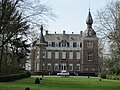
Château Pecsteen -

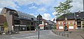
Brasserie Sint-Antonius -
 La route.
 -
 Vue panoramique.
 -
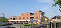 Le parking.
 -
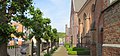 L'église.


